Thursday 20 December 2012

A Festive Blog

I started this blog about a year ago and have managed more or less one per month. I had a bet (a plate of oysters) with Sarah Nice from the BGS Communications Team, that no one would bother to read it. Well,  I lost my bet as I now have several thousand readers, not a hard price to pay and the oysters were a first for Sarah.

BGS continues to do well despite the hard financial times and tight budgets from government. Nonetheless, our science outputs have increased  this year, both in the conventional literature and on the web and in smart apps.

I encourage you to lake a look at our report for the last financial year and the presentations at our recent 2012 stakeholder meeting at the Geological Society of London.

I wish you all a happy Christmas and all the best for 2013 and thanks for reading the blogs; I will keep them coming in 2013!

Tuesday 18 December 2012

The last blog from AGU 2012 (better late than never)!


By Wednesday I was suffering a little from mid week saturation, as there are only a certain number of science presentations that one can take in in a day. Below shows the poster display along with one from BGS in a special session on education in geosciences, where we are producing a digital set of 3Dfossil images with other archives and museums in the UK.


Data and dealing with lots of it, is a big problem that underpins many sessions here. Increasing demand for open data and the ability to mash-up diverse data sets and create new environmental research areas and services is an important part of the mix here. The UK is a leader with its virtual environment observatory concept.  Unifying management protocols and making data transferable, although perhaps not the exciting end of science delivery, is one of the most important aspects of science showcased by BGS here.

I also spent some time in a session on Tsunami where BGS made a number of presentations and where there was a focus on the March 2011 Tohoku-oki tsunami in Japan and how we can learn from this event and plan for future events. We are well respected for our specialist geological role in understanding the geomorphology and sedimentology of these events.

I also attended the honours banquet where senior and mid career scientist are recognised for their contributions to our science. It is always good to celebrate success and this sort of recognition is important for academics who generally work extremely hard and are not as highly paid as industry counterparts.

Our staff have given 48 science presentations which is an excellent showing for BGS at AGU and underpins our increasingly robust role in earth and environmental science.


Thursday 6 December 2012

More News from AGU 2012


Three days into the meeting and there is a lot going on. Some say that there will be more than 20000 people attending this week. The AGU meeting brings together a very broad group of scientists ranging from planetary science to all aspects of environmental science including the study of the deep earth. In reality although BGS has a broad science remit, we probably do not cover more than 15% of the activity types here.
Nonetheless on Monday and Tuesday, BGS scientists were involved in a number of events. Many were presenting at poster sessions, which is a form of presentation of science, where you stand in front of a display of science ideas. There are hundreds of posters each day, they are well attended and a great way of communicating science.  
Geovisionary at AGU 2012

BGS have been demonstrating geological mapping technology of the UK, how volcanoes formed in Mexico, what are the sources of magnetic anomalies on Earth, redefining the best practice in high resolution geochronology, living with atmospheric electricity, using geophysics to understand the structure of volcanoes and much more.
The meeting is also a good place to bring together planning boards for large projects.  There have been several sessions on the future of scientific drilling, both in the oceans through the Integrated Ocean Drilling Program (IODP) and the continents with the International Continental Scientific Drilling Program  (ICDP). BGS leads as a science operator in this science and has some key scientific targets which underpin areas such as past climate change as a model for the future high CO2 world, developing deep geothermal energy and understanding the Arctic as a geological province for science discovery and for future resources. As BGS director I sit on a number of management boards that meet at AGU and to an extent I miss out on the fun parts of the science when attending these sessions.
Evenings are punctuated by a number of “townhall” meetings to announce science strategy and US universities bringing their past graduates together: all of these tend to be good events to meet people and exchange scientific ideas in a lively atmosphere.
Me at Fishermans Wharf, San Francisco, on my way to a "townhall" meeting

Tuesday 4 December 2012

BGS at the American Geophysical Union Fall Meeting


The American Geophysical Union (AGU) meeting in San Francisco is the largest yearly gathering of geoscientists, ranging from those studying the deep interior of the Earth to the envelopes surrounding the Earth. Staff from the British Geological Survey, have from time to time, attended the meeting. Following the BGS strategic push to become more involved in modelling geological and environmental sciences we have seen a significant increased visibility of our staff at this meeting. This year we have numerous presentations involving BGS staff at this top level meeting. A summary of the BGS presentations can be found here.  I will be providing updates throughout the meeting via the blog and on Twitter @BGSBoss #AGU12

Thursday 25 October 2012

A forward look for Earth Sciences (and keeping frogs in a wheelbarrow)

I have just come back from a meeting that BGS organised on behalf of the European Earth Sciences community in Paris. For the first time we managed to get senior scientists from all sectors of the earth sciences together to design our needs for the future: these ranged from the Geological Surveys  through the major agencies delivering earth sciences research to some of the brightest scientists, both starting out and senior, recognised as fellows by the European Research Council

With the breadth of egos in the room, "herding cats" or "keeping frogs in a wheel barrow" come to mind as expressions. Well, we managed to achieve a lot and the output of the meeting will be open to the community to comment on, with an outward facing statement on the types of research and infrastructure needed for our science and its importance and impact being prepared for European Geosciences Union 2013.  This will be coupled with an earth science community based document representing our road map as a guide for the future; both for funding, but more importantly, for consolidation of  the community and sharing of infrastructure and creation of joint science programmes in which the spectrum of our scientists from government agencies to research in universities and the private sector will share.

I thought that the director of Earth sciences from the French CNRS, Michel Diament and one of the co-organisers summarised our aims well in stating that:

People like to dream: about the origin of the Earth, the universe and life.
People Want to be safe: from natural hazards especially catastrophic events
People want to be comfortable: to have a secure supply of energy, water and raw materials

Earth sciences research helps underpin all of this.

Friday 28 September 2012

The Ice Man Cometh


The British Geological Survey (BGS) has over the past few years undertaken a series of observations related to glaciers in Iceland. In addition to monitoring volcanic processes (such as those from the Eyjafjallajökull volcano that erupted from under a glacier and severely disrupted European air traffic in 2010), BGS with partners from Iceland and other UK universities have been monitoring glaciers with respect to their stability in a changing climate regime. 

Location of the BGS Glacial Observatory at Virkisjökull/ Falljökull in southeast Iceland
In particular, this suite of glaciers located on the south eastern extremity of Iceland may be susceptible to changes in temperature related to sea water temperature and sea current regimes. This week the BGS chief scientist, Professor Denis Peach, visited the observatory with BGS staff and discussed further developments in monitoring. In particular, they propose to look at groundwater in a suite of drill holes on the edge and toe of the glacier and listening to the glacier's movements with seismic and acoustic arrays.

BGS Chief Scientist, Professor Denis Peach, visits the Iceland Glacier Observatory
BGS with other earth science national laboratories across Europe recently met to design a coordinated earth science infrastructure programme of monitoring.  It will build on the complementary nature of observing networks throughout Europe and will look at applying solid earth monitoring programmes (normally used for volanoes, landslides and earthquakes) to environmental problems, focussing on glacial movement and structure and the stability of permafrost and the mass balance in erosion processes.

The Iceland observatory is one node of a multi node development across Europe and the globe.

Tuesday 21 August 2012

A Blog from Down Under


Every four years the geologists from around the world get together in an International Geological Congress (IGC) which was held this year in Brisbane Australia. It's a long haul from the UK, but it's increasingly necessary to be present outside of Europe and North America as we start to see real globalisation of our science.

Entrance to the IGC at the Brisbane Convention and Exhibition Centre
Increasingly science research programmes that were dominated by western subscriptions are being joined by memberships from Brazil, China and India. We are starting to see significant investments in geological research in these and other countries, not only to underpin their natural resources, but also to educate their young scientists. One notable movement is the Young Earth Scientists (YES) network that will be meeting with the IGC. YES focus on up to date media such as webinars, blogs and social media to communicate; the formal lecture being slower and reaching fewer scientists.

IGC on reducing carbon emissions


A significant focus of the IGC meeting in Brisbane was on energy supply and security. How can we reduce our dependence on carbon as coal, oil and gas, for energy? These sources of energy are very efficient.  They have high calorific values and are relatively easy to transport, but 30 billion tonnes of carbon per year are injected into the atmosphere and have resulted in an increase in global carbon dioxide (CO2) in the atmosphere from 280 ppm to nearly 400 ppm since the industrial revolution.

Over the same period the population of the planet has grown to 7 billion. Expected demand for energy as this population grows and demands better living standards, will at the very minimum double to 1000 exajoules per year. We must reduce emissions. 

Coal burning produces about twice the CO2 output of gas power stations and a significant part of the reduction could then come from conversion to gas power plants that are fed from potential gas reserves held tightly in sediments, called shale gas; the USA uses 200 trillion cubic meters of gas per year and now more than half comes from shale gas. There is a consensus among geologists that shale gas is a potential resource that will significantly extend our dependence on carbon related energy, but at the same time we must make energy use efficiencies and use non carbon sources from energy, including nuclear, geothermal, solar and wind production. Australia plan to include a significant geothermal part in their energy mix, currently they do not produce any energy this way.

Geological surveys will play an important role in defining shale gas reserves, geothermal sources, radioactive waste repositories, subsurface energy storage and infrastructure for wind-farms. Transparency and publication of operational practices and research results is mandatory.

Very dynamic geology in New Zealand


After my visit to Brisbane, I am now in New Zealand at GNS Science having discussions on the International Continental Drilling Project (ICDP).  This is the most active geological environment on Earth as New Zealand sits astride the Alpine fault which cuts across the country dividing the Australian plate from the Pacific plate. The collision between the two is at about 5 cm a year year (50 meters in a thousand years) and the mountains are created by uplift and erosion with 12 meters rainfall on west side of alpine fault and as low as 30 cm the other side resulting in a sharp contrast in relief, erosion and vegetation West to East across the country.

It is an earthquake prone region and the recent Christchurch earthquake although not as large as some earthquakes, has resulted in significant damage, a large part of the city will have to be abandoned and relocated. This damage was mostly due to a process called liquefaction, which liquidises the shallow sediments as a result of shaking of water saturated sediments. This is why a detailed understanding of the shallow subsurface and how it behaves in earthquakes is needed to better manage the risk of damage.


Friday 20 July 2012

Communicating Uncertainty - how certain are we about being uncertain?

Geology is a science, but not what one would define as an "exact science". While we are increasingly applying mathematical principles to geology, one of the biggest challenges is quantifying how well we understand the natural world. This is frustrating for us, but is even more frustrating for the public and industry who want accurate information on which to base decisions. The most obvious example in the natural sciences is in weather forecasting, which is increasingly accurate and is fed by satellite imagery and complex numerical models, but is subject to error. This feeds into climate modelling for which international agencies are adding and modelling more and more variables but for which uncertainties remain.

In geology we define geological contacts between units and we place a line in a map when we have identified this in the field, in most places the contacts are inferred and are shown as dotted lines. The extrapolation to depth is even more uncertain and can be improved by geophysical measurements and validated by drilling.

In general that is how geology works, mapping of units from satellite images and aerial photos, validation in the field and presentation in a geological map; which is now a digital map and is increasingly a 3 dimensional digital geological map. Where resources need to be defined the mapping is followed up by geophysical images and ultimately by drilling to define the true geological contacts.

This is the bulk of the geologist's job and we know what the confidence is in our geological images and geophysical models. The challenge is communicating this to the public in a world where we will be increasingly using the subsurface space to build, to store things such as gas and heat, to extract resources and to secure nuclear waste and avoid emission of waste CO2 from power stations by underground storage. There is no doubt that public pressure on defining the environmental consequences of these activities is increasing and geologists will be required to provide robust models of the subsurface if we are to convince them about the science that we do.

BGS is working on creating a 3 dimensional geological map of the UK which will vary in resolution depending on where you are in the UK. It will be high resolution below the major cities where the upper 100's of meters are critical for construction, ultra-high resolution in the proposed UK nuclear waste repositories, potential CO2 storage reservoirs and in future areas of resource exploitation. In other areas BGS will focus on high level landscape models allowing for protection and understanding of the UK geological heritage, farming development and modelling of flood risk and other natural hazards.

Only where we have observed a geological contact will the locations be exact otherwise we will always need to infer contacts and build geological scenarios to the best of our abilities.

Thursday 17 May 2012

Introducing the British Geological Survey’s Environmental Science Centre

The British Geological Survey has existed for more than 175 years and has been based in numerous locations around the UK.  Its head office moved out of London in the 1970s and relocated to Keyworth in Nottinghamshire, about six miles south-east of Nottingham.  It occupied a teachers training college, the Mary Ward College, that was due to be closed down.  Initially the site stayed pretty much as it was, but throughout the 1990s BGS built additional laboratory facilities and warehouses for the national collections.  It wasn't until 2005 that BGS began to remove the old college residences and teaching facilities; by 2009 the William Smith Building was completed and was opened by HRH The Princess Royal.
The William Smith Building at the BGS Headquarters in Keyworth


We have now completely renovated the site and this week we will open the British Geological Survey, Environmental Science Centre. This is our flagshipsite with the new James Hutton Building being the centrepiece, paying homage to James Hutton.  It has a representation of the famous unconformity at Siccar Point at its entrance, which gave Hutton the proof that the present is the key to the past.  In addition we have renovated the reception area in the Kingsley Dunham Building which houses the De la Beche lecture theatre and Library and created state of the art conference suite and modern exhibition centre.


The National Geological Repository has been extended and will hold several hundred km of core from the UK mainland and continental shelf. This repository is a world-class facility open to all for teaching, research and optimising commercial development of the UK landmass and continental shelf.  


Most excitingly, along the spine of the campus we have created the BGS Geological Walk which celebrates the more than three billion year geological history of the United Kingdom with examples of igneous, sedimentary and metamorphic rocks.  The walk is arranged as a geological timeline and has rocks representing England, Scotland Wales and Northern Ireland.  There are some interesting features such as the homage to Stonehenge, the Hutton unconformity at Siccar Point and the 39 types of flagstones from all across the UK.
The BGS Geological Walk and James Hutton Building
This latest phase of construction cost 17.2 million pounds and this, along with the William Smith Building, brings the investment made by the Natural Environment Research Council (NERC), UK to 25 million pounds in the Keyworth site over the past ten years. I thank the NERC for this underpinning confidence in the British Geological Survey. 


We are extending the use of the Environmental Science Centre and have started the development of an innovation hub by creating BGS International  and also in welcoming PANalytical, a subsidiary of Spectris plc, onto the site.  We will be opening the site to other private sector companies and government agencies.  

The new BGS Environmental Science Centre will be opened by Sir John Beddington, the government’s chief scientist who will be introduced by the NERC's Chief Executive Duncan Wingham.

It is a new beginning for BGS and I would like to thank all of those involved in the construction, in particular, the BGS staff on site for their patience while the building phases have been completed.  The site will be open to visitors during BGS office hours and we invite you to browse the BGS shop, the modern exhibition centre, have a bite and a drink in our canteen and walk the BGS Geological Walk more than three billion years of geological history.


Monday 19 March 2012

BGS Global Geoscience

The BGS works around the world on geoscience projects. These projects involve the application of BGS geological and environmental expertise in developing countries to help create a geological information system of maps and databases that will underpin the future economic development of a country's resources in water, soil, mineral or energy supply. 

Recent BGS Global Geoscience projects include geological mapping in the United Arab Emirates, a national programme of geochemical mapping in Nigeria and a research project with an international team involving plate tectonics and volcanism in the Afar Rift.

These are funded by sources such as the World Bank, foreign governments and private sector, European funding and research funding from the UK, including baseline funding from the Natural Environment Research Council (NERC).

To facilitate our global reach and increase our flexibility in working with clients, BGS has recently created a company which trades as BGS International Ltd. The BGS and other scientists will work in this company in the service sectors of geology.

BGS Global Geoscience will also develop research projects as an added value in association with BGS International when appropriate.


Geological Survey of India (GSI)
The BGS has not in recent years had a sustained collaborative agreement with the Geological Survey of India (GSI)  and in a recent visit I met with the GSI to discuss future roles for BGS Global Geoscience and that of BGS International.

The GSI rightly argues that India must have large undiscovered resource reserves and compares itself to resource-rich countries such as Canada, South Africa and Australia where resources make up close to 8 per cent of GDP; in India they are less than 2 per cent.

New investments in geological survey should provide the basis for industry to identify target areas of future investment. At the same time any exploitation needs to be completed using state-of-the-art technology and environmental protection.

As a result of my visit, BGS has since sent staff to the GSI to initiate a dialogue on the latest technologies in data management.  

The future for GSI, and all geological surveys, will require us increasingly to be linked and networked into large data management systems across the world.

Indian National Centre for Antarctic & Ocean Research
I also visited India through the National Centre for Antarctic & Ocean Research (NCAOR)   India will be renewing its involvement  in the international scientific drilling research community through the Integrated Ocean Drilling Program (IODP).

The BGS plays a lead role in Europe in provision of drilling capability for the European arm of the IODP and with the involvement of India we will focus on key targets related to the future hydrocarbon resources in the Indian marine shelf and also in the Indian Ocean in general. 

We will also try and solve some fundamental questions related to transport of sediments from the Himalayas to the Indian Ocean and the rate of uplift and erosion of the Himalayan Mountains providing us with clues to how the mountain range was formed.

The BGS through its Global Geoscience  programme will develop new initiatives in India, which still has, hidden in its landmass, enormous potential in natural resources and also geological discovery in general.

Thursday 12 January 2012

Looking back a year


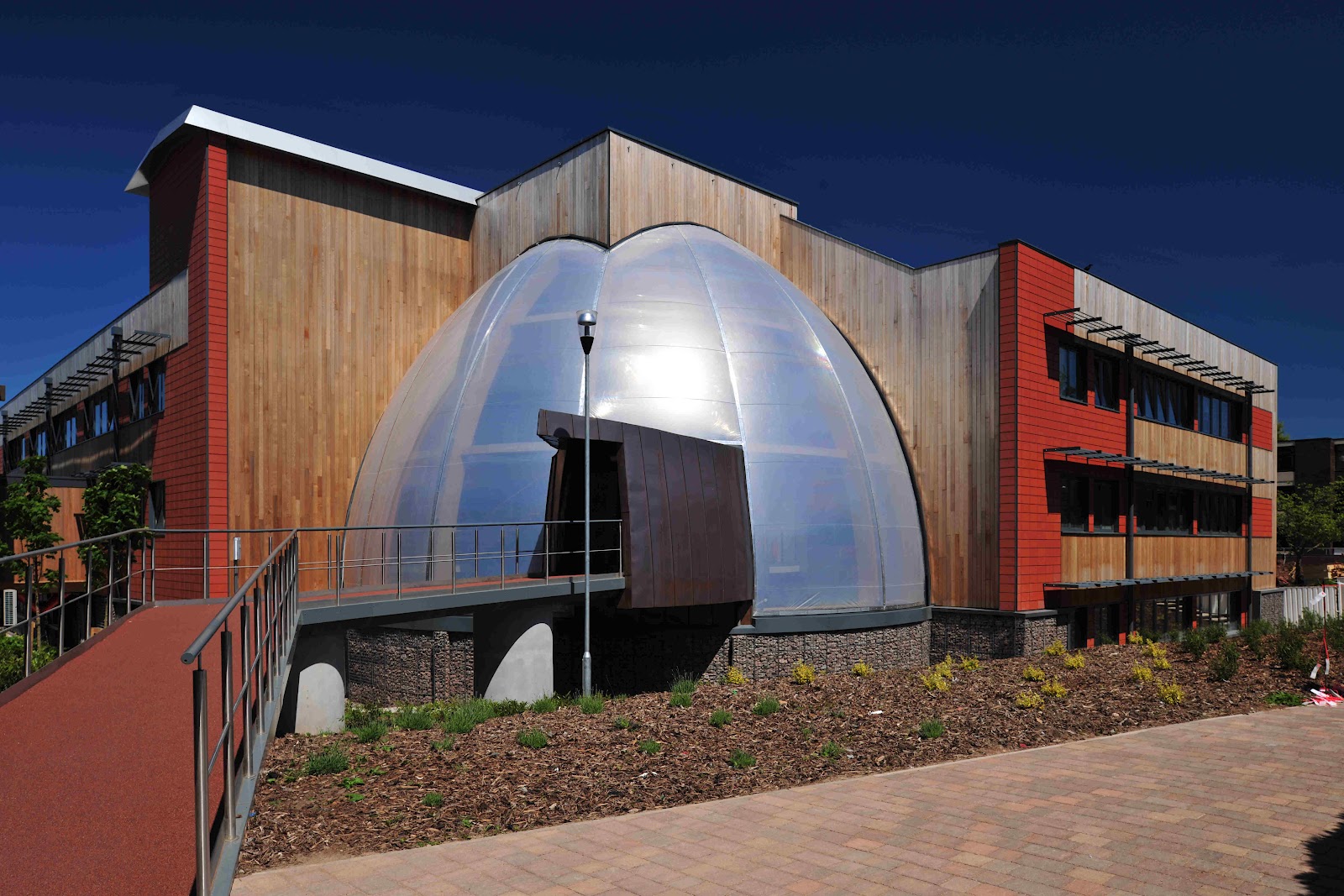
The new James Hutton Building, BGS Keyworth,
that includes a number of energy saving features:
photovoltaic cells on the roof, rainwater harvesting for the toilets
and a Micro-CHP (Combined Heat + Power) plant.
The building has an Energy Performance Certificate (EPC) 'A'
rating and a BREEAM'excellent' rating.

Reading the last issue of Nature for 2011 I was reminded of the number of events in which a detailed knowledge of the Earth system and decisions based on geological science were essential:

 The world's population reached seven billion, reflecting the ever increasing need for resources to house, feed and transport humankind.

Food reached a record cost early in the year and in March the planet was struck by one of the largest earthquakes in recent times.

At the same time there was only limited progress on improvements in our ability to manage the planet into the future through agreements such as those that came out of the climate summit in Durban in December.

In May the British Geological Survey led a discussion at the Geological Society of London on the 'Anthropocene' and  asked the question about the human influence on the planet:
'is our imprint on the planet no longer reversible and if so, should we declare a new geological epoch?'
Declaration of an epoch of course also implies that this time period will have an end in which humans no longer affect the planet: we may have become extinct; we may have fled and colonised other worlds and I leave this to the reader's imagination!

Food production requires careful management of water resources, much of which comes from groundwater, and fertilisers that are mined and for which important regulation of impurities is a health factor to be considered. Desertification, deforestation and pollution of the surface and subsurface through intensive agriculture all must be carefully monitored by geologists and ecologists.

Fuel for thought
The Tohoku earthquake, Japan was much larger than had been modelled as being probable in the region; the 'big-one' was expected to hit further south of Tokyo (and we must be mindful  that this risk is still very real). This event was offshore in a known zone of tectonic plate collision, but its intensity indicates that we have much to learn about the physics of the planet.

Also we should not forget that large earthquakes (although they may be some 200 times smaller than the Japanese one) can cause incredible damage and loss of life in the interiors of continental regions and are in fact more damaging and less understood.

Although the earthquake, and the associated tsunami, killed thousands of people, the focus of attention of the world's press was on the Fukushima nuclear plant. Thankfully Fukushima is now safe, but it will take decades to clean up the site.

Many countries, including the UK, have since reviewed their nuclear power generation schemes.  Nuclear technology will continue to provide a significant source of energy as we move further into the 21st century. Moving away from nuclear sources towards coal, oil and gas, the only short- medium-term replacement, only exacerbates the greenhouse gas emissions unless these are captured and sequestered.

Storage of nuclear waste, extracting hydrocarbons, and Carbon Capture and Storage (CCS) require a very thorough understanding of the subsurface of our planet and this is the overarching role of the geologist. Further geological research and survey is essential for making the right decisions on our energy future.

Recover and recycle

In 2012, as we wait for the world's economy to recover, there will be increased demand for resources to feed, house and transport our people. While we will need new resources in strategic metals, hydrocarbons and building materials, we must focus on:
  • recycling
  • better insulation
  • more effective transport
  • renewable energy
  • better water/soil/forest management etc.
For example let's think seriously about more efficient magnets in high-tech and energy applications, before we rush to mine metals from the sea-floor without a thorough understanding of the consequences.

On behalf of the staff of the British Geological Survey, I wish all of our partners and users of our geological information a very prosperous 2012.